Location: Green Mountain, North Carolina (in Yancey County) – in field directly opposite the local cemetery
Date Occurred: Saturday night, June 11, 2005
Date Discovered: Sunday morning, June 12, 2005
Crop: 3-1/2′ – 4′ tall mature hay (ready for cutting)
Dimensions: A perfect 176 ft.-diam. circle, with a precisely located central swirl (88′ from the center to edge, measured along 12 radii)
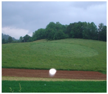 Details: Farmer had been planting tobacco in a nearby section of the field until 8:30 pm Saturday night and, when he left the field, no circle was present. The following day was “Decoration Day” (a day when local residents routinely visit their cemetery to tidy it up and place fresh flowers on the graves); when residents arrived at the cemetery immediately after church services
they discovered the circle near the crest of the ridge above the tobacco field. The farmer and first visitors state they observed no tracks or footprints leading into or near the circle, and the lay of the crop was very tight to the ground. There are no houses immediately close to the field and, so far, there are no reports of EM interference, or unusual animal disturbance. This is the first crop circle reported to BLT in this area of the Blue Ridge section of the Appalachian Highlands (Yancey County has the highest average elevation of any county in North Carolina). Because the hay was mature the farmer has now cut the field.
On Sunday afternoon (6/12/05) Marc Whitson, a local resident, drove by the formation to take some photos at about 7 – 7:30 pm. It was getting close to dusk and some storm clouds were gathering but it was not raining and examination of his photos seems to indicate the flash did not discharge. Multiple small semi-transparent orbs and a few brighter and more opaque orbs appeared on several of his photographs which–if the flash did not discharge–cannot be explained as moisture droplets or dust reflecting the light from the flash close to the lens.
Onsite Investigation of Crop Circle
7-2-05
Tom Ginther
Weaverville, NC
54 foot circle
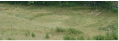 We drove from Asheville to an area north and west of Weaverville well off of route 70 north to a rural area where a cul-de-sac is being developed. We arrived about 1:30 about 300 yards above the circle on a hill side. I scrambled down the hillside and later back up. The circle was in a bottom about 30 yards from what we think is Eller Creek in meadow grass. The owner said it was a hay field that had not been cut for some time and there was a fence around part of it. There was evidence that four wheelers had been using a path that ran through here and next to the circle crossing the creek for a long time. A tractor had driven to the circle area down a single path, did a loop at the circle location then back out the same path. After considering the tracks did not appear to be on top of the area of the circle that the path indicated, I believe the tractor was there before the circle was created; according to the first witness to see it this was between 6/22 pm and 6/23 am. According to the witness/land owner no one in the area heard or saw anything strange at that time and he had no reason to think that it was hoaxed. We later found out we were able to drive down to the circle and did that, it cannot be done with out four wheel drive. Other people were there to look at the circle the same day we were, they were not investigating but just curious friends of the owner.
- Looked for layers in the circle: Found a single layer, with most of the green grass lifting back up and some stems reorienting themselves back to the sun; some node turning.
- Swirl direction: found the crop to be layered clockwise with the exception of part of the south section between the tractor tracks which was counter clockwise, about a 3 foot wide swath. It appeared to have been swirled from the outside in to the center with an unfinished oval center about two foot wide, with a single standing stalk at the off center end.
- Is there a center: unfinished center, oval shaped, two foot off center, did not finish up into a single tight swirl. 4. Size: 54 foot as measured from all directions.
- Electro- magnetic energy: did not affect a compass, a TriField meter set on both microwave or magnetic did not detect anything.
- Any unusual plants: some of the nodes on the grass stems in the circle did have some lengthening, but the same plants from as much as 150 feet away looked the same. There was some node bending in the green plants, but since this was 10 days after the event, and these were plants raised off of the ground, it appeared the plants were reorienting back up towards the sun.
- Pictures: took 31 pictures and did not notice any anomalies.
- Magnet drag: Did four magnet drags with a rare earth magnet and used 4 plastic bags. 1 around the center, 1 around the mid-point, 1 around the inside edge, 1 about 30 feet around the outside of the circle. Will examine on 7/5. This circle has some of the items one would look for in a genuine crop circle, but I was unable to examine it until ten days after its formation and a number of people had been walking in it before I got there. I would say it appears to be real and would have to ask why someone would hoax one in a location where almost no one would see it.
*Names have been changed to protect privacy.